Continuing to fix each state’s Congressional Districts, we arrive at the last state with two Representatives: Hawaii.
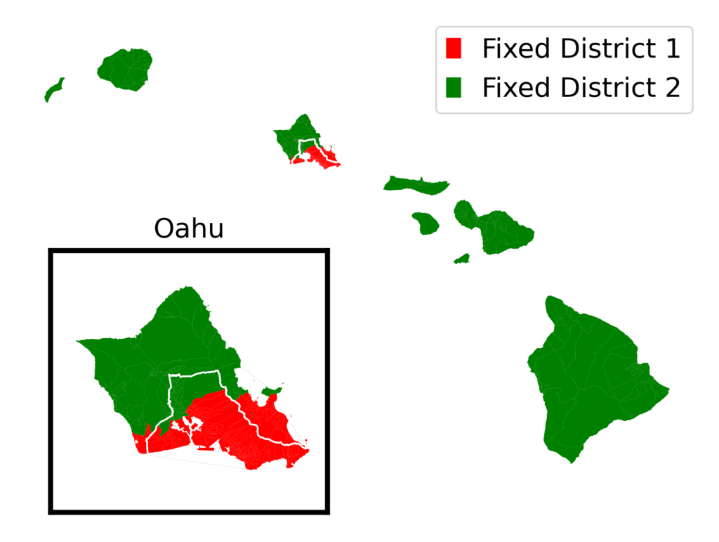
Suggested new Congressional Districts for Hawaii
The fair districts that I designed (District 1 in red, District 2 in green) line up fairly well with the official districts (labeled and divided by a white line). My District 1 includes the coastal cities of Kailua and Kaneohe instead of the center-island cities of Miliani and Wahaiwa. Remember that I drew these districts with no reference to official districts, so it’s not a surprise that mine are a little different.
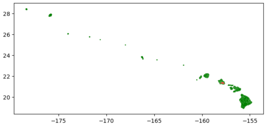
Hawaii was also a particularly interesting state to map. Here is what the map looked like straight out of the box:
I had to crop out all the uninhabited islands, zoom in on the inhabited ones, fix all the coastlines (like I did with Florida) and add an inset for Oahu so you could see District 1 clearly. Here is part of the Python script to generate the inset map:
It was fun.
Thirteen states down, thirty-seven to go. Up next: the first of two states with three Representatives. The more representatives a state has, the more fun it is to ungerrymander!
Continuing to fix each state’s Congressional Districts, one by one, we come to Maine:
Suggested new Congressional Districts for Maine (red and green), along with the boundary between the official new districts (white) and the twin cities of Auburn and Lewiston (yellow)
The fair districts that I designed (District 1 in red, District 2 in green) line up fairly well with the official districts (labeled and divided by a white line). The biggest difference is the same thing we saw in New Hampshire: cities split between districts in the official districts, and unified in my districts. In this case, the cities are Maine’s largest city of Portland and the twin cities of Auburn and Lewiston. Both are in District 1 in my map.
Twelve states down, thirty-eight to go. Up next: probably the hardest state to map.
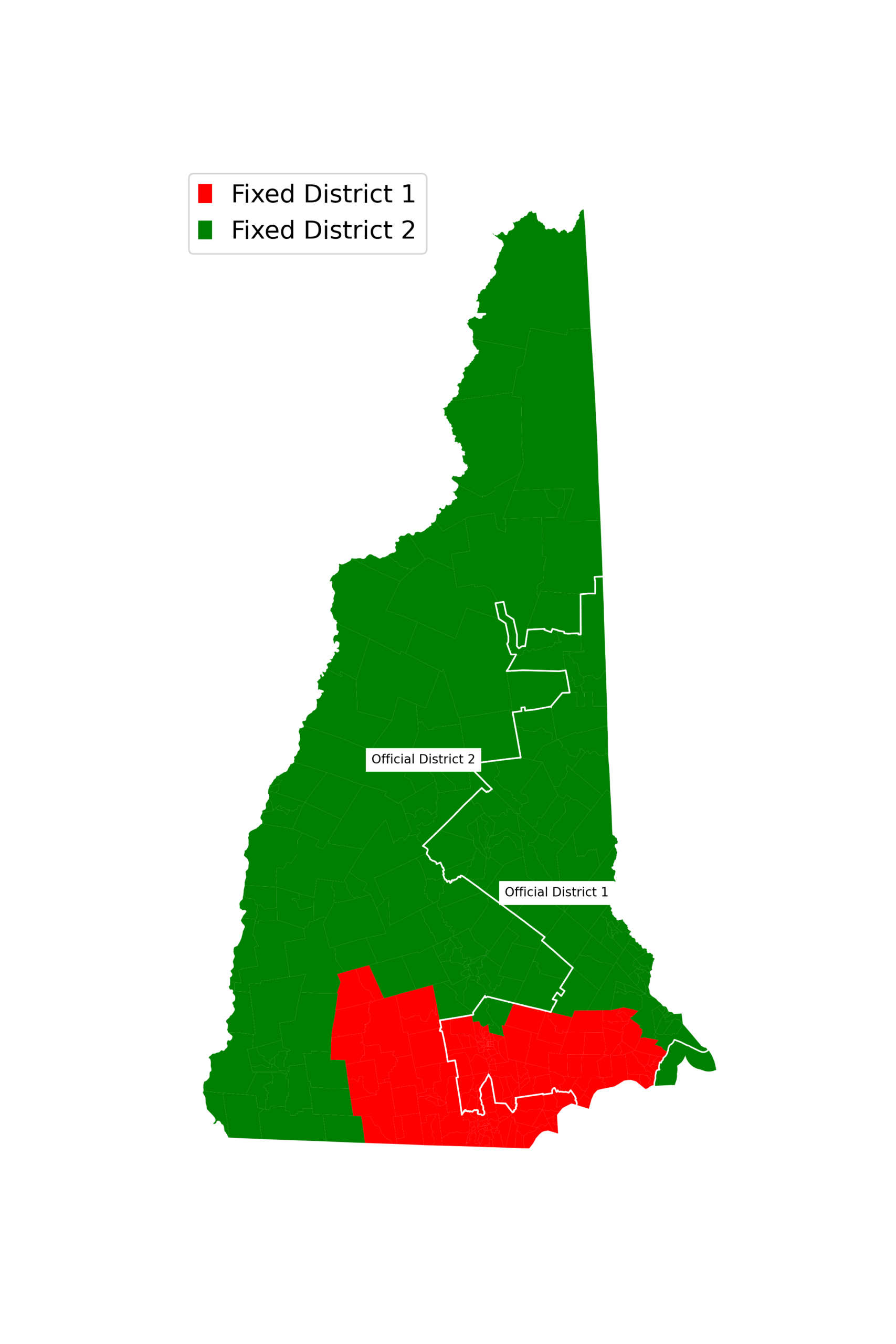
Continuing my series about reversing gerrymandering and creating fair congressional districts – last Wednesday I fixed New Hampshire. Today, let’s take a deeper look at the Granite State:
One thing you might have noticed in last Wednesday’s map was a weird protrusion sticking out like a wang on the southeastern part of the state. That’s because, as we saw earlier this month with Florida, the geographic shapefile included incorrect coastlines – it included the Atlantic Ocean between the New Hampshire mainland and tiny White Island. In today’s map, I fixed that shapefile.
If you look at the southern part of the state, you’ll see the other change – one that shows an important insight that we will see over and over again as we go through states.
I have labeled in yellow borders the two largest cities in New Hampshire. Manchester holds 8 percent of the state’s total population, and Nashua holds another 7 percent. In the state’s official Congressional districts (border shown by the white line), Manchester and Nashua are in separate districts. In my fair districts, both are in District 1 (red).
It makes sense that I would put both in the same district: my organizing principle is to keep similar areas together. Manchester and Nashua have more in common with one another than they do with the rest of the state, which is mostly rural.
We’ll see this over and over again, with increasing levels of ridiculousness, as we look at bigger and bigger states: government-approved districts split urban areas – deliberately keeping people who live in cities from being represented.
Continuing our gerrymandering series after a long layoff, with another state with two Congressional Districts:
Suggested new Congressional Districts for New Hampshire (red and green), along with the boundary between the official new districts (white)
Most of New Hampshire’s population is concentrated in the southern part of the state, so it makes sense that one fair district would include the south and one would include the rest of the state.
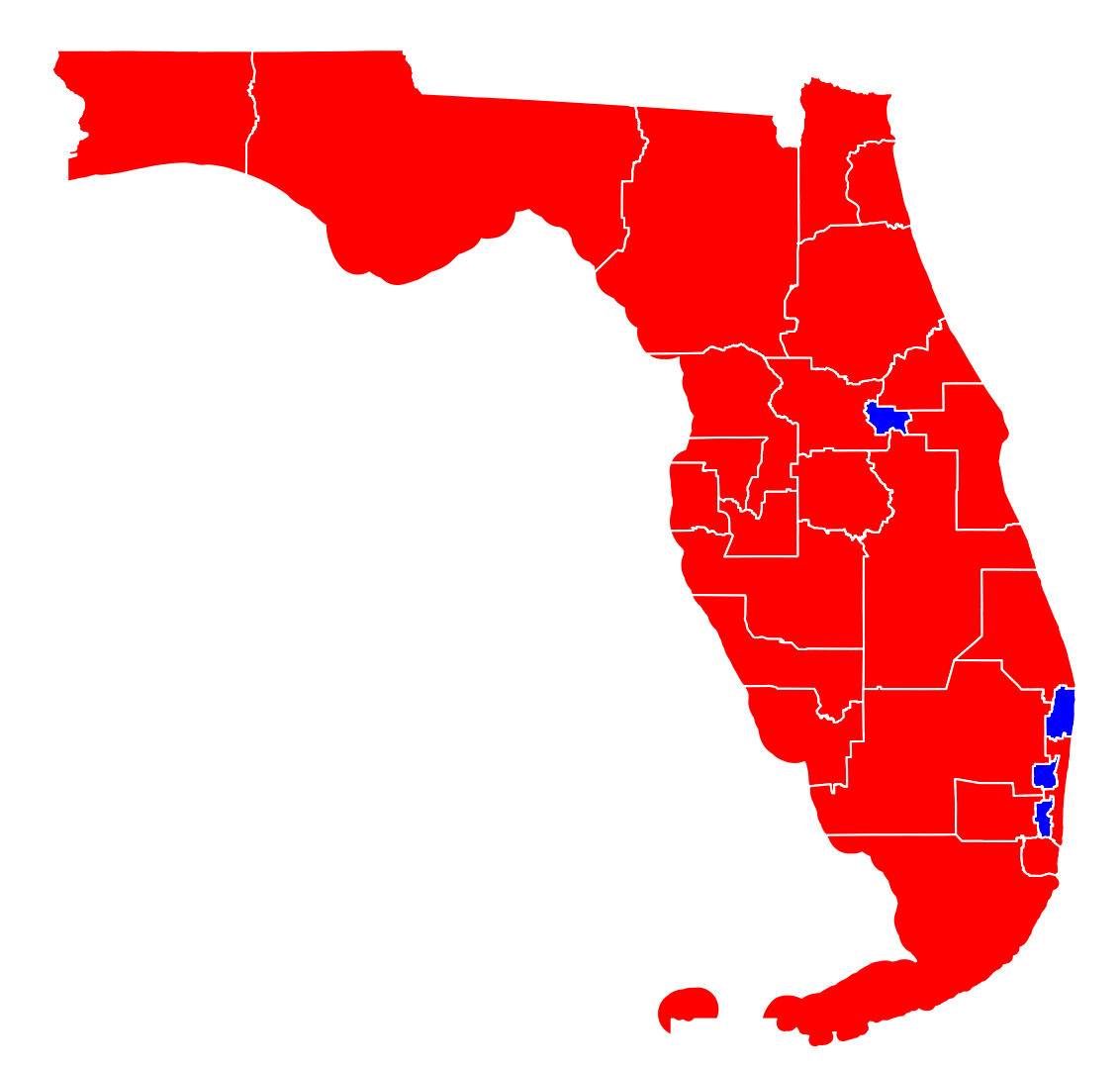
Over the next few months, you’ll hear a lot about the proposed new Congressional Districts in Florida. You’ve probably seen a map of the proposed new districts, and it probably looks like this (red districts will likely vote Republican, blue districts will likely vote Democratic):
Which is to say, it doesn’t look like Florida at all. The Keys are now a giant peninsula? Tampa Bay disappeared? I know I can do better.
Governor Ron DeSantis’s office designed new districts with the explicit goal of electing more Republican U.S. Representatives. DeSantis signed the new districts into law last Monday, although the new districts have already been challenged in court. If the courts allow, the new districts will be used in the 2026 House election.
And so, I did. I can explain in a lot more detail if you are interested, but basically I trimmed the edges of this map with the coast of Florida, as defined by the U.S. Census Bureau Shapefiles. And here is the result, which actually looks like a map of Florida:
If you’re interested, I can produce larger version, a version with districts labeled, or any other changes you can imagine. Email me if you’d like to see it.
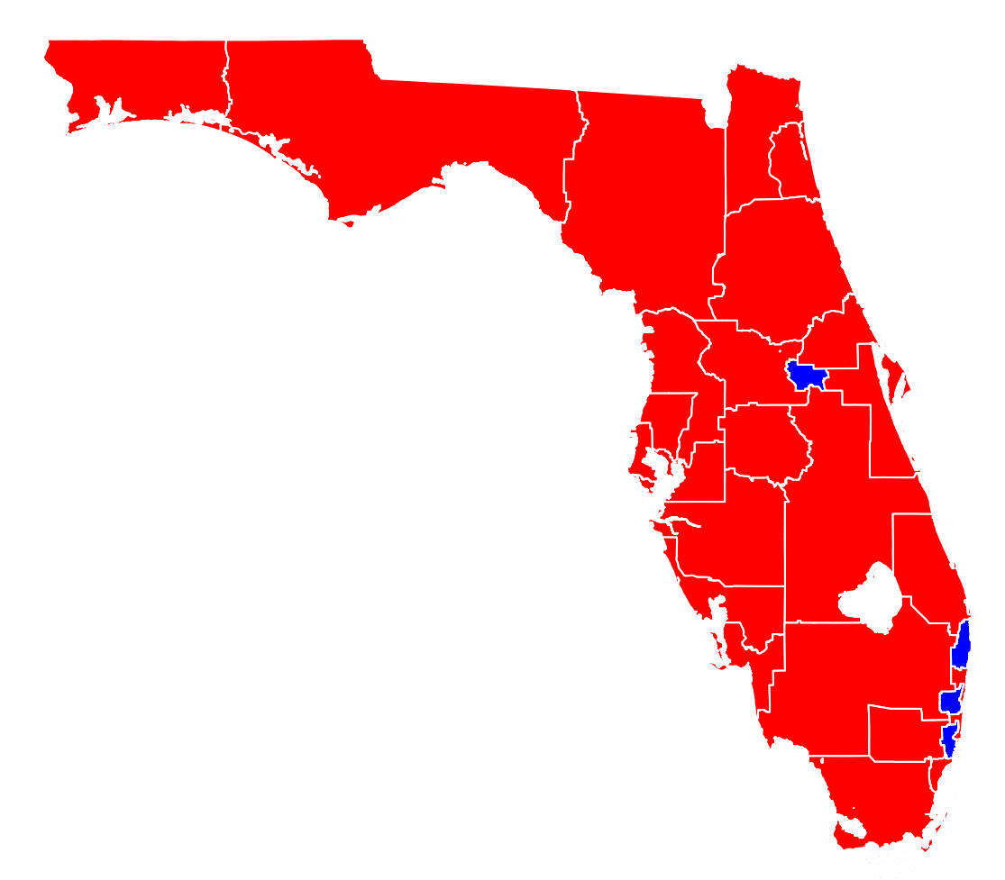
This is a good map of Florida, and an accurate representation of the new districts. While it’s an accurate representation, it’s not a fair representation. Becuase, say it with me: LAND DOESN’T VOTE! PEOPLE VOTE!
A fair representation would show each district the same size, because each district gets one voting representative in the House of Representatives. I have been proudly making those maps for years now, and the same approach can make a fair map of Florida’s proposed new districts:
It’s still a massive Republican majority (20-4 based on 2024 election results), but at least the Democratic districts don’t look so pathetically small.
So which representation is the best? Definitely not the one you’ve seen in the media, which yeets Tampa Bay. The map that looks like Florida, with accurate coastlines, accurately shows where in Florida votes come from. The map of equal-sized districts, accurately shows who represents Florida in the House of Representatives. As always, the answer depends on the research question!
Want to try it yourself? Download the scripts and Illustrator files from my GitHub repository! If you want to make the plots yourself, sign up for an account on SciServer.org, create a container, and upload the Ipython file. Happy mapping!