Ungerrymandering Nebraska

The more Congressional districts a state has, the more fun the state is to gerrymander. And so we arrive at the first state with three districts: Nebraska. A third district requires a third color code – District 1 is red, District 2 is green, and District 3 is orange.
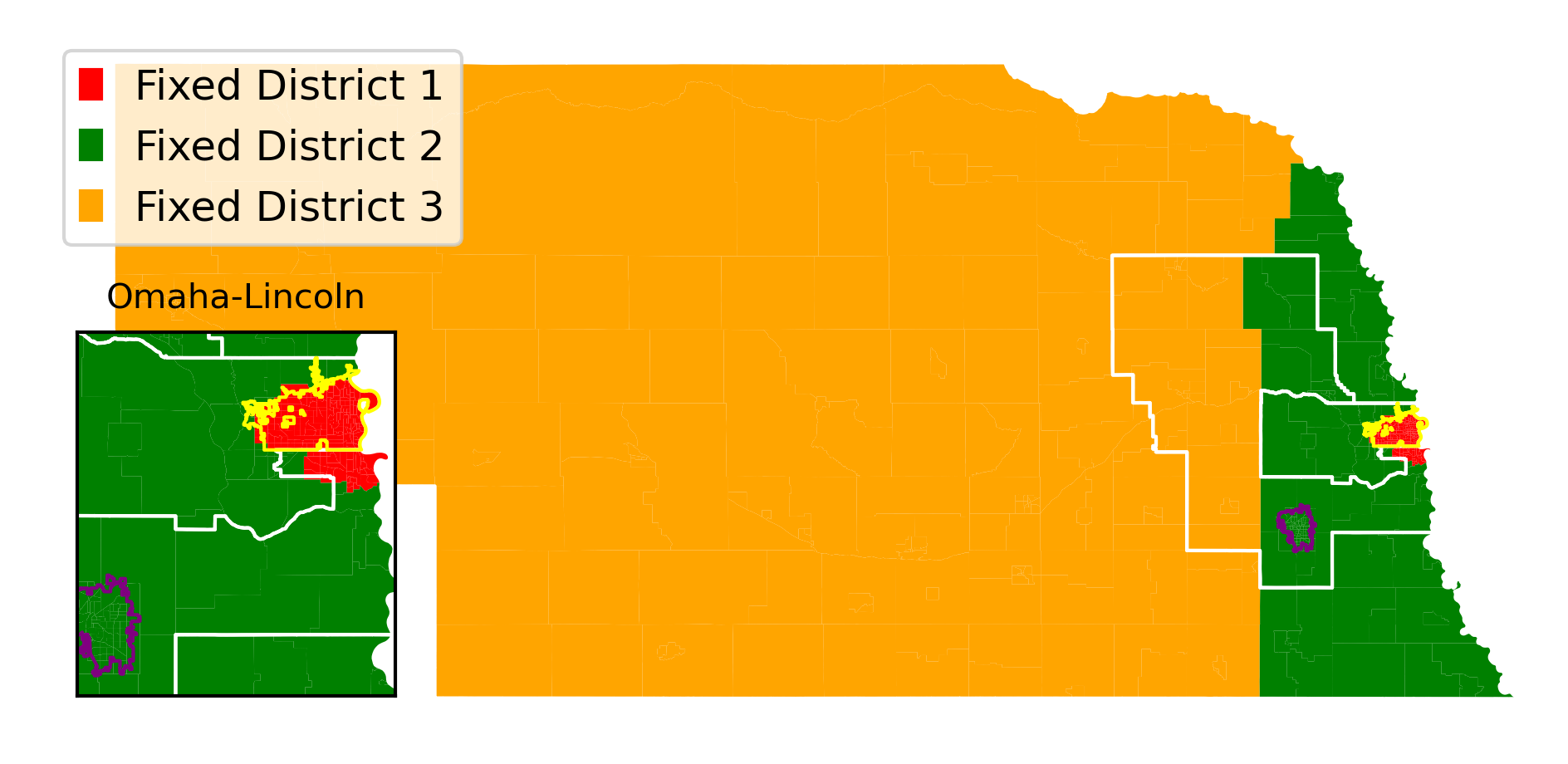
Suggested new Congressional Districts for Nebraska

Remember that, as always, I made these districts in an attempt to fairly represent the population of Nebraska, with no consideration of voting patterns. I started in the largest city (Omaha) and moved out. District 1 is the most urban (Omaha-en) and District 3 is the most rural.

The inset at the bottom left shows the two largest urban areas in Nebraska: Omaha and Lincoln, collectively holding 40 percent of the population of Nebraska. Notice how the boundaries of Omaha (yellow border) line up with District 1 in both my new districts (red color) and the actual Nebraska congressional districts (white borders).

That is the exception. As we go through states, we’ll see urban areas split among districts over and over again. It’s nice to see it not happen for once.

Previous ungerrymanders:
Introduction
Idaho
Montana
Rhode Island
West Virginia
New Hampshire (and again)
Maine
Hawaii
Ungerrymandering Hawaii

Continuing to fix each state’s Congressional Districts, we arrive at the last state with two Representatives: Hawaii.

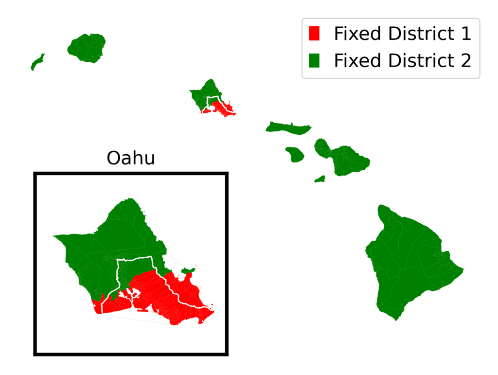
Suggested new Congressional Districts for Hawaii

The fair districts that I designed (District 1 in red, District 2 in green) line up fairly well with the official districts (labeled and divided by a white line). My District 1 includes the coastal cities of Kailua and Kaneohe instead of the center-island cities of Miliani and Wahaiwa. Remember that I drew these districts with no reference to official districts, so it’s not a surprise that mine are a little different.

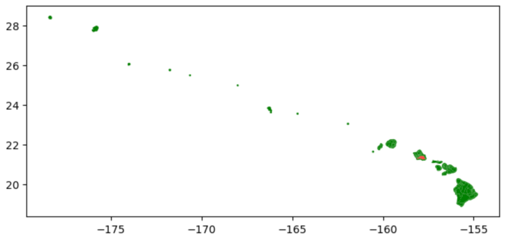
Hawaii was also a particularly interesting state to map. Here is what the map looked like straight out of the box:

I had to crop out all the uninhabited islands, zoom in on the inhabited ones, fix all the coastlines (like I did with Florida) and add an inset for Oahu so you could see District 1 clearly. Here is part of the Python script to generate the inset map:

It was fun.

Thirteen states down, thirty-seven to go. Up next: the first of two states with three Representatives. The more representatives a state has, the more fun it is to ungerrymander!

Previous entries:
Introduction
Idaho
Montana
Rhode Island
West Virginia
New Hampshire (and again)
Maine

Ungerrymandering Maine

Continuing to fix each state’s Congressional Districts, one by one, we come to Maine:

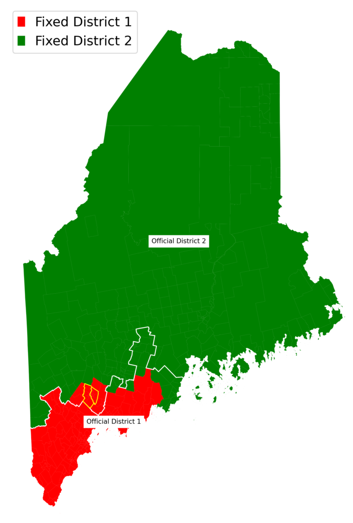
Suggested new Congressional Districts for Maine (red and green), along with the boundary between the official new districts (white) and the twin cities of Auburn and Lewiston (yellow)

The fair districts that I designed (District 1 in red, District 2 in green) line up fairly well with the official districts (labeled and divided by a white line). The biggest difference is the same thing we saw in New Hampshire: cities split between districts in the official districts, and unified in my districts. In this case, the cities are Maine’s largest city of Portland and the twin cities of Auburn and Lewiston. Both are in District 1 in my map.

Twelve states down, thirty-eight to go. Up next: probably the hardest state to map.

Previous entries:
Introduction
Idaho
Montana
Rhode Island
West Virginia
New Hampshire (and again)

New Hampshire, Anew

Continuing my series about reversing gerrymandering and creating fair congressional districts – last Wednesday I fixed New Hampshire. Today, let’s take a deeper look at the Granite State:

One thing you might have noticed in last Wednesday’s map was a weird protrusion sticking out like a wang on the southeastern part of the state. That’s because, as we saw earlier this month with Florida, the geographic shapefile included incorrect coastlines – it included the Atlantic Ocean between the New Hampshire mainland and tiny White Island. In today’s map, I fixed that shapefile.

If you look at the southern part of the state, you’ll see the other change – one that shows an important insight that we will see over and over again as we go through states.

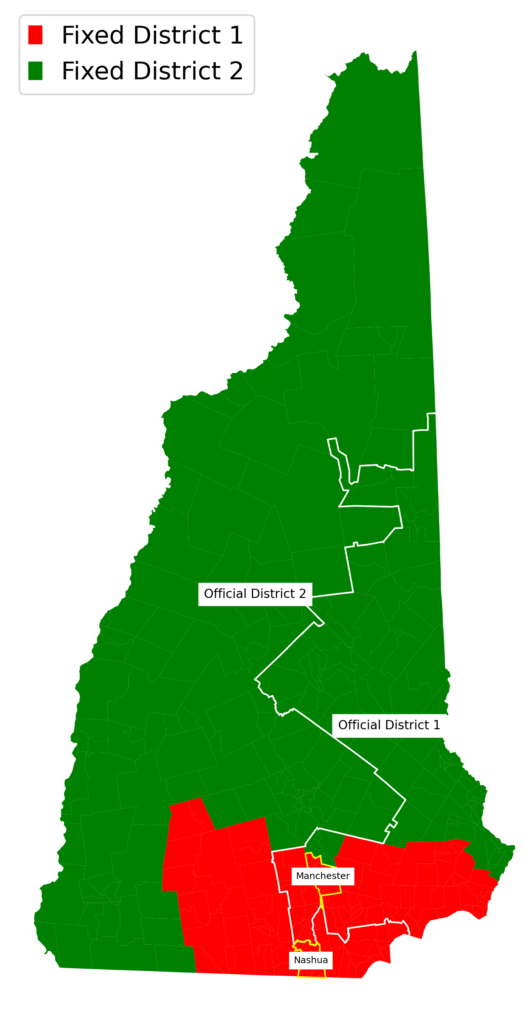
I have labeled in yellow borders the two largest cities in New Hampshire. Manchester holds 8 percent of the state’s total population, and Nashua holds another 7 percent. In the state’s official Congressional districts (border shown by the white line), Manchester and Nashua are in separate districts. In my fair districts, both are in District 1 (red).

It makes sense that I would put both in the same district: my organizing principle is to keep similar areas together. Manchester and Nashua have more in common with one another than they do with the rest of the state, which is mostly rural.

We’ll see this over and over again, with increasing levels of ridiculousness, as we look at bigger and bigger states: government-approved districts split urban areas – deliberately keeping people who live in cities from being represented.

There I fixed it: Ungerrymandering New Hampshire

Continuing our gerrymandering series after a long layoff, with another state with two Congressional Districts:

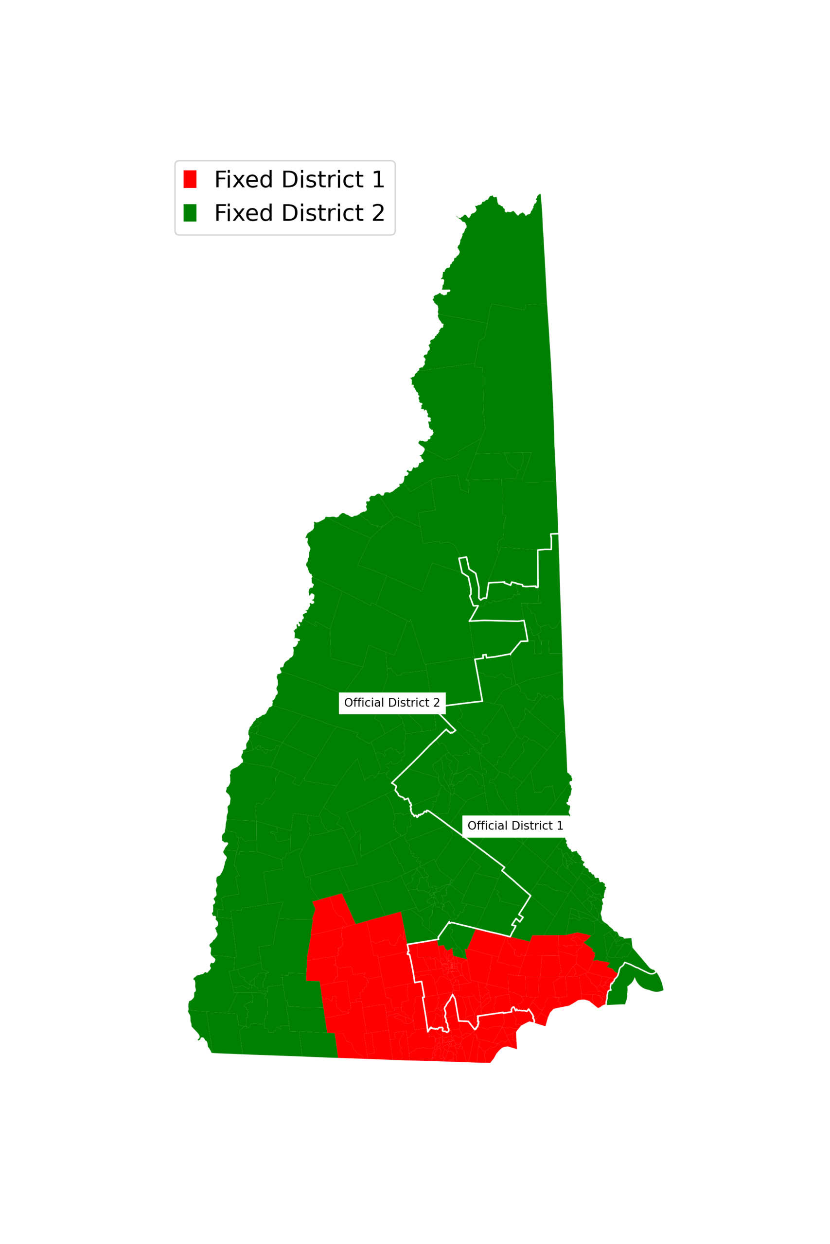
Suggested new Congressional Districts for New Hampshire (red and green), along with the boundary between the official new districts (white)

Most of New Hampshire’s population is concentrated in the southern part of the state, so it makes sense that one fair district would include the south and one would include the rest of the state.

Eleven states fixed, thirty-nine to go.

Previous entries:
Introduction
Idaho
Montana
Rhode Island
West Virginia